ZIP Code 5: 02809 - BRISTOL, RI
ZIP Code 02809 is the postal code in BRISTOL, RI. Besides the basic information, it also lists the full ZIP code and the address of ZIP code 02809. Whatsmore, there is more information related to ZIP Code 02809. For example, nearby ZIP code around ZIP Code 02809, etc.
ZIP 02809 Basic Information

The basic information of ZIP Code 02809 is as follows, including: country, county, city, FIPS and etc.
| State | County | City | ZIP Code 5 |
|---|---|---|---|
| RI - Rhode Island | Bristol County | BRISTOL | 02809 |
What is the plus 4 zip code for 02809 ZIP Code? Below is the detail.
02809 ZIP+4 Code List

What are the 4 digit zip extensions of ZIP Code 02809? ZIP code 02809 has many plus 4 codes, and each plus 4 code corresponds to one or more addresses. Below we list all the ZIP+4 codes and their addresses in the ZIP Code 02809. You can find a 9-digit ZIP Code by a full address.
| ZIP Code 5 Plus 4 | Address |
|---|---|
| 02809-0001 | PO BOX 1 (From 1 To 74), BRISTOL, RI |
| 02809-0081 | PO BOX 81 (From 81 To 199), BRISTOL, RI |
| 02809-0201 | PO BOX 201 (From 201 To 319), BRISTOL, RI |
| 02809-0321 | PO BOX 321 (From 321 To 409), BRISTOL, RI |
| 02809-0411 | PO BOX 411 (From 411 To 499), BRISTOL, RI |
| 02809-0501 | PO BOX 501 (From 501 To 615), BRISTOL, RI |
| 02809-0621 | PO BOX 621 (From 621 To 735), BRISTOL, RI |
| 02809-0900 | PO BOX 1050, BRISTOL, RI |
| 02809-0901 | PO BOX 1080, BRISTOL, RI |
| 02809-0902 | PO BOX 1000 (From 1000 To 1020), BRISTOL, RI |
- Page 1
- ››
Post Office in ZIP Code 02809

BRISTOL is the only post office in ZIP Code 02809. You can find the address, phone number, and interactive map below. Click to view the service and service hours about BRISTOL.
-
BRISTOL Post Office

Address 515 HOPE ST, BRISTOL, RI, 02809-9998
Phone 401-253-5821
*Street Parking Available
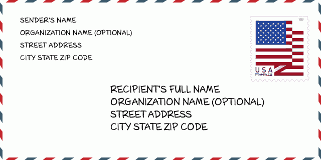
How to write a U.S. envelope?

-
First, you need to fill in the recipient's mailing information in the center of the envelope. The first line is the recipient's name, the second line is the street address with a detailed house number, and the last line is the city, state abbr, and ZIP Code.
Second, write the sender's information on the left top corner of the envelope. If your mail cannot be delivered, it will return to the sender's address.
Finally, don't forget to stick the stamp on the right top corner. Otherwise, the letter will not go into the delivery process.
Here is the envelope example below.
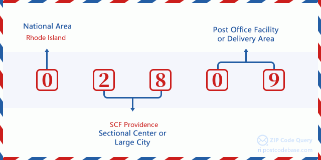
What does each digit of ZIP Code 02809 stand for?
-
The first digit designates a national area, which ranges from zero for the Northeast to nine for the far West.
The 2-3 digits represent a sectional center facility in that region.
The last two digits designate small post offices or postal zones.
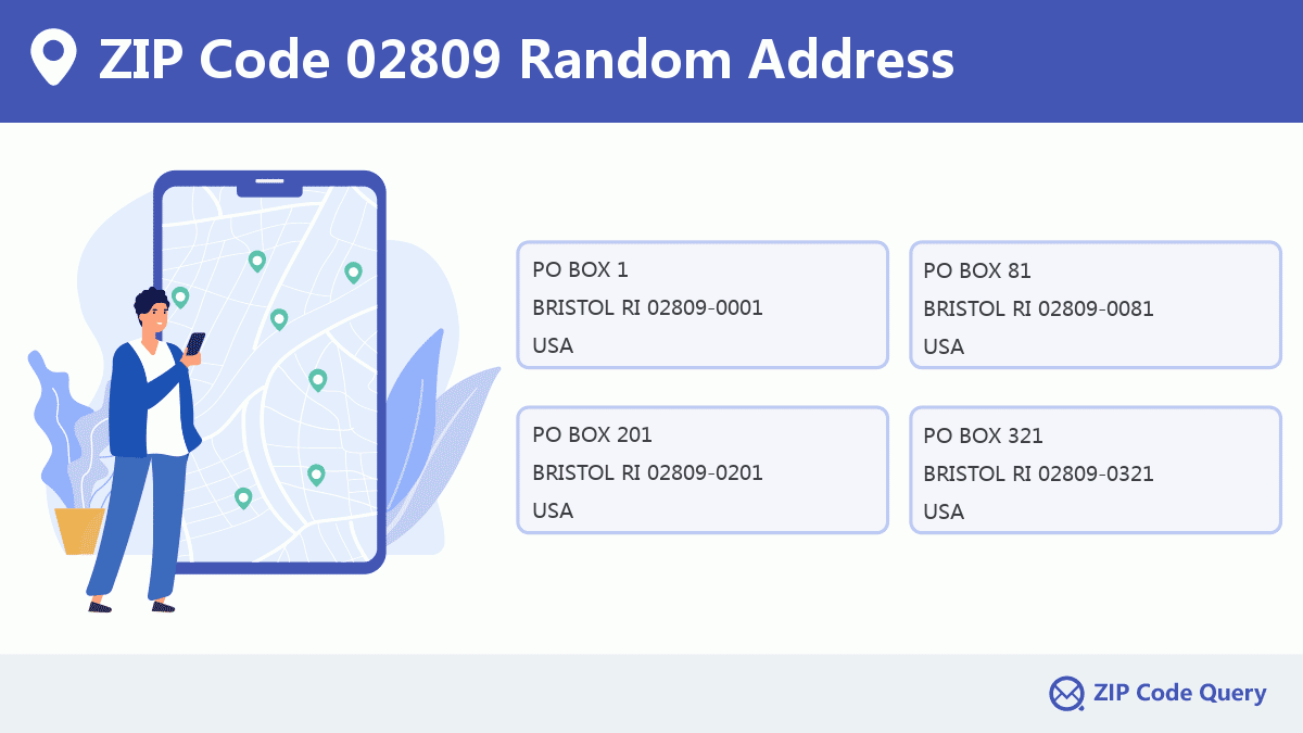
Random Address in ZIP 02809

ZIP Code 02809 has 3,813 real random addresses, you can clicking the picture below to get random addresses in ZIP Code 02809.
ZIP 02809 Online Map

This is online map of the address BRISTOL, Bristol County, Rhode Island. You may use button to move and zoom in / out. The map information is for reference only.
ZIP 02809 NearBy ZIP Code
The Nearby ZIP Codes are 02885, 02724, 02806, 02872, and 02777, you can find ZIP codes in a 25km radius around ZIP Code 02809 and the approximate distance between the two ZIP codes.
The data has a slight deviation for your reference only.
| ZIP Code | Distance (Kilo Meters) |
|---|---|
| 02885 | 5.822 |
| 02724 | 7.605 |
| 02806 | 8.117 |
| 02872 | 8.18 |
| 02777 | 8.855 |
| 02887 | 9.143 |
| 02725 | 9.382 |
| 02722 | 9.912 |
| 02721 | 10.294 |
| 02889 | 10.411 |
| 02871 | 10.438 |
| 02878 | 11.141 |
| 02723 | 11.793 |
| 02915 | 12.776 |
| 02726 | 13.281 |
| 02888 | 14.055 |
| 02720 | 14.707 |
| 02886 | 16.075 |
| 02905 | 16.099 |
| 02914 | 16.657 |
| 02841 | 17.129 |
| 02910 | 17.383 |
| 02790 | 17.429 |
| 02818 | 17.632 |
| 02842 | 17.951 |
| 02801 | 18.06 |
| 02907 | 18.214 |
| 02715 | 18.26 |
| 02771 | 18.427 |
| 02769 | 18.464 |
| 02852 | 18.822 |
| 02920 | 19.224 |
| 02903 | 19.353 |
| 02916 | 19.602 |
| 02912 | 19.745 |
| 02893 | 19.955 |
| 02901 | 20.034 |
| 02902 | 20.034 |
| 02940 | 20.034 |
| 02835 | 20.447 |
| 02906 | 20.464 |
| 02702 | 20.727 |
| 02837 | 20.901 |
| 02909 | 21.747 |
| 02747 | 21.928 |
| 02764 | 21.975 |
| 02840 | 22.002 |
| 02921 | 22.499 |
| 02908 | 22.687 |
| 02918 | 22.932 |
| 02861 | 23.286 |
| 02779 | 23.386 |
| 02791 | 23.874 |
| 02823 | 23.919 |
| 02904 | 23.993 |
| 02874 | 24.151 |
| 02862 | 24.157 |
| 02860 | 24.185 |
| 02714 | 24.467 |

Museum in ZIP Code 02809

-
LINDEN PLACE
Phone: (401) 253-0390Discipline: Historical Societies, Historic PreservationAddress: 500 HOPE STREET, BRISTOL RI 02809, USA
Library in ZIP Code 02809

-
ROGERS FREE LIBRARY
Phone: (401) 253-6948Address: 525 HOPE STREET, BRISTOL RI 02809, USA
School in ZIP Code 02809

This is the ZIP Code 02809 - School page list. Its detail School Name, Address, City, State, ZIP Code is as below.
| School Name | Address | City | State | Grades | ZIP Code |
|---|---|---|---|---|---|
| Byfield School | 220 High Street | Bristol | Rhode Island | KG-2 | 02809 |
| Colt-andrews School | 570 Hope Street | Bristol | Rhode Island | 3-5 | 02809 |
| Guiteras School | 35 Washington Street | Bristol | Rhode Island | KG-5 | 02809 |
| Mt. Hope High School | 199 Chestnut Street | Bristol | Rhode Island | 9-12 | 02809 |
| Reynolds School | 235 High Street | Bristol | Rhode Island | KG-5 | 02809 |
| Rockwell School | 1225 Hope Street | Bristol | Rhode Island | PK-3 | 02809 |
Comment


Add new comment