ZIP Code 5: 02816 - COVENTRY, RI
ZIP Code 02816 is the postal code in COVENTRY, RI. Besides the basic information, it also lists the full ZIP code and the address of ZIP code 02816. Whatsmore, there is more information related to ZIP Code 02816. For example, nearby ZIP code around ZIP Code 02816, etc.
ZIP 02816 Basic Information

The basic information of ZIP Code 02816 is as follows, including: country, county, city, FIPS and etc.
| State | County | City | ZIP Code 5 |
|---|---|---|---|
| RI - Rhode Island | Kent County | COVENTRY | 02816 |
What is the plus 4 zip code for 02816 ZIP Code? Below is the detail.
02816 ZIP+4 Code List

What are the 4 digit zip extensions of ZIP Code 02816? ZIP code 02816 has many plus 4 codes, and each plus 4 code corresponds to one or more addresses. Below we list all the ZIP+4 codes and their addresses in the ZIP Code 02816. You can find a 9-digit ZIP Code by a full address.
| ZIP Code 5 Plus 4 | Address |
|---|---|
| 02816-0001 | PO BOX 1 (From 1 To 60), COVENTRY, RI |
| 02816-0002 | PO BOX 61 (From 61 To 99), COVENTRY, RI |
| 02816-0003 | PO BOX 121 (From 121 To 180), COVENTRY, RI |
| 02816-0004 | PO BOX 200 (From 200 To 240), COVENTRY, RI |
| 02816-0005 | PO BOX 241 (From 241 To 299), COVENTRY, RI |
| 02816-0006 | PO BOX 301 (From 301 To 360), COVENTRY, RI |
| 02816-0007 | PO BOX 361 (From 361 To 399), COVENTRY, RI |
| 02816-0008 | PO BOX 421 (From 421 To 480), COVENTRY, RI |
| 02816-0009 | PO BOX 500 (From 500 To 540), COVENTRY, RI |
| 02816-0010 | PO BOX 541 (From 541 To 599), COVENTRY, RI |
- Page 1
- ››
Post Office in ZIP Code 02816

COVENTRY is the only post office in ZIP Code 02816. You can find the address, phone number, and interactive map below. Click to view the service and service hours about COVENTRY.
-
COVENTRY Post Office

Address 1550 NOOSENECK HILL RD, COVENTRY, RI, 02816-9998
Phone 401-821-7208
*Lot Parking Available
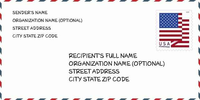
How to write a U.S. envelope?

-
First, you need to fill in the recipient's mailing information in the center of the envelope. The first line is the recipient's name, the second line is the street address with a detailed house number, and the last line is the city, state abbr, and ZIP Code.
Second, write the sender's information on the left top corner of the envelope. If your mail cannot be delivered, it will return to the sender's address.
Finally, don't forget to stick the stamp on the right top corner. Otherwise, the letter will not go into the delivery process.
Here is the envelope example below.
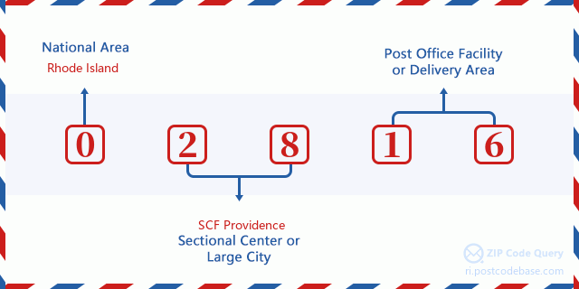
What does each digit of ZIP Code 02816 stand for?
-
The first digit designates a national area, which ranges from zero for the Northeast to nine for the far West.
The 2-3 digits represent a sectional center facility in that region.
The last two digits designate small post offices or postal zones.
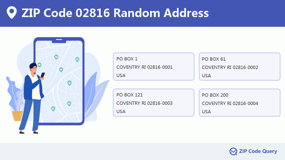
Random Address in ZIP 02816

ZIP Code 02816 has 4,574 real random addresses, you can clicking the picture below to get random addresses in ZIP Code 02816.
ZIP 02816 Online Map

This is online map of the address COVENTRY, Kent County, Rhode Island. You may use button to move and zoom in / out. The map information is for reference only.
ZIP 02816 NearBy ZIP Code
The Nearby ZIP Codes are 02831, 02817, 02827, 02823, and 02815, you can find ZIP codes in a 25km radius around ZIP Code 02816 and the approximate distance between the two ZIP codes.
The data has a slight deviation for your reference only.
| ZIP Code | Distance (Kilo Meters) |
|---|---|
| 02831 | 7.53 |
| 02817 | 7.551 |
| 02827 | 7.555 |
| 02823 | 8.6 |
| 02815 | 8.951 |
| 02893 | 10.542 |
| 02825 | 11.84 |
| 02921 | 12.459 |
| 02818 | 14.299 |
| 06373 | 14.319 |
| 02857 | 14.494 |
| 02886 | 14.641 |
| 02822 | 15.665 |
| 06377 | 15.792 |
| 02920 | 16.268 |
| 06354 | 17.593 |
| 02919 | 17.91 |
| 02852 | 18.651 |
| 02910 | 19.15 |
| 02898 | 19.26 |
| 02877 | 19.333 |
| 02888 | 19.665 |
| 02889 | 20.295 |
| 02892 | 20.731 |
| 06239 | 20.799 |
| 02907 | 20.916 |
| 06384 | 21.009 |
| 02909 | 21.214 |
| 02887 | 21.357 |
| 02829 | 21.86 |
| 06243 | 21.882 |
| 02828 | 22.043 |
| 02905 | 22.292 |
| 02911 | 22.438 |
| 06374 | 22.697 |
| 02832 | 22.717 |
| 06332 | 22.804 |
| 02908 | 23.094 |
| 02903 | 23.401 |
| 02901 | 23.544 |
| 02902 | 23.544 |
| 02940 | 23.544 |
| 06387 | 23.66 |
| 02918 | 23.713 |
| 02873 | 23.901 |
| 02814 | 23.977 |
| 02874 | 24.03 |
| 02812 | 24.399 |
| 02904 | 24.399 |
| 02912 | 24.42 |

Library in ZIP Code 02816

-
COVENTRY PUBLIC LIBRARY
Phone: (401) 822-9100Address: 1672 FLAT RIVER ROAD, COVENTRY RI 02816, USA
School in ZIP Code 02816

This is the ZIP Code 02816 - School page list. Its detail School Name, Address, City, State, ZIP Code is as below.
| School Name | Address | City | State | Grades | ZIP Code |
|---|---|---|---|---|---|
| Blackrock School | 12 Lacasa Drive | Coventry | Rhode Island | KG-5 | 02816 |
| Coventry High School | 40 Reservoir Road | Coventry | Rhode Island | 9-12 | 02816 |
| Flat River Middle School | 1675 Flat River Road | Coventry | Rhode Island | 6-8 | 02816 |
| Hopkins Hill School | 95 Johnson Boulevard | Coventry | Rhode Island | PK-5 | 02816 |
| Knotty Oak Middle School | 15 Foster Drive | Coventry | Rhode Island | 6-8 | 02816 |
| Little Oaker Pre-school | 40 Reservoir Road | Coventry | Rhode Island | PK-PK | 02816 |
| Oak Haven School | 46 Pettine Street | Coventry | Rhode Island | KG-5 | 02816 |
| Tiogue School | 170 East Shore Drive | Coventry | Rhode Island | PK-5 | 02816 |
| Washington Oak School | 801 Read School House Road | Coventry | Rhode Island | PK-5 | 02816 |
| Western Coventry School | 4588 Flat River Road | Coventry | Rhode Island | KG-5 | 02816 |
Comment


Add new comment