ZIP Code 5: 02857 - NORTH SCITUATE, RI
ZIP Code 02857 is the postal code in NORTH SCITUATE, RI. Besides the basic information, it also lists the full ZIP code and the address of ZIP code 02857. Whatsmore, there is more information related to ZIP Code 02857. For example, nearby ZIP code around ZIP Code 02857, etc.
ZIP 02857 Basic Information

The basic information of ZIP Code 02857 is as follows, including: country, county, city, FIPS and etc.
| State | County | City | ZIP Code 5 |
|---|---|---|---|
| RI - Rhode Island | Providence County | NORTH SCITUATE | 02857 |
What is the plus 4 zip code for 02857 ZIP Code? Below is the detail.
02857 ZIP+4 Code List

What are the 4 digit zip extensions of ZIP Code 02857? ZIP code 02857 has many plus 4 codes, and each plus 4 code corresponds to one or more addresses. Below we list all the ZIP+4 codes and their addresses in the ZIP Code 02857. You can find a 9-digit ZIP Code by a full address.
| ZIP Code 5 Plus 4 | Address |
|---|---|
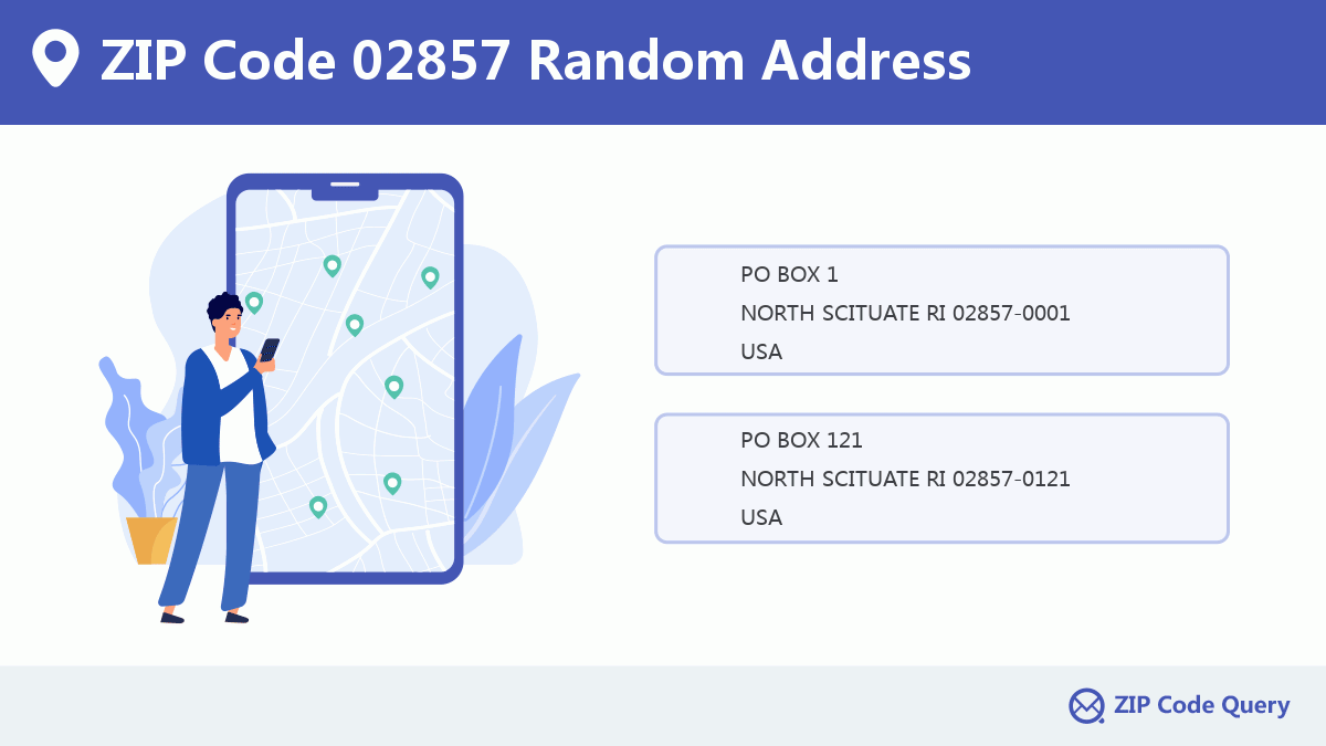
| 02857-0001 | PO BOX 1 (From 1 To 120), NORTH SCITUATE, RI |
| 02857-0121 | PO BOX 121 (From 121 To 239), NORTH SCITUATE, RI |
| 02857-0241 | PO BOX 241 (From 241 To 359), NORTH SCITUATE, RI |
| 02857-0391 | PO BOX 391 (From 391 To 477), NORTH SCITUATE, RI |
| 02857-0478 | PO BOX 479, NORTH SCITUATE, RI |
| 02857-0481 | PO BOX 481 (From 481 To 540), NORTH SCITUATE, RI |
| 02857-0541 | PO BOX 541 (From 541 To 630), NORTH SCITUATE, RI |
| 02857-0631 | PO BOX 631 (From 631 To 690), NORTH SCITUATE, RI |
| 02857-0691 | PO BOX 691 (From 691 To 751), NORTH SCITUATE, RI |
| 02857-0751 | PO BOX 752 (From 752 To 786), NORTH SCITUATE, RI |
- Page 1
- ››
Post Office in ZIP Code 02857

NORTH SCITUATE is the only post office in ZIP Code 02857. You can find the address, phone number, and interactive map below. Click to view the service and service hours about NORTH SCITUATE.
-
NORTH SCITUATE Post Office

Address 175 DANIELSON PIKE, NORTH SCITUATE, RI, 02857-1961
Phone 401-647-9215
*Street Parking Available
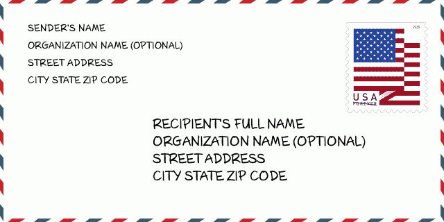
How to write a U.S. envelope?

-
First, you need to fill in the recipient's mailing information in the center of the envelope. The first line is the recipient's name, the second line is the street address with a detailed house number, and the last line is the city, state abbr, and ZIP Code.
Second, write the sender's information on the left top corner of the envelope. If your mail cannot be delivered, it will return to the sender's address.
Finally, don't forget to stick the stamp on the right top corner. Otherwise, the letter will not go into the delivery process.
Here is the envelope example below.
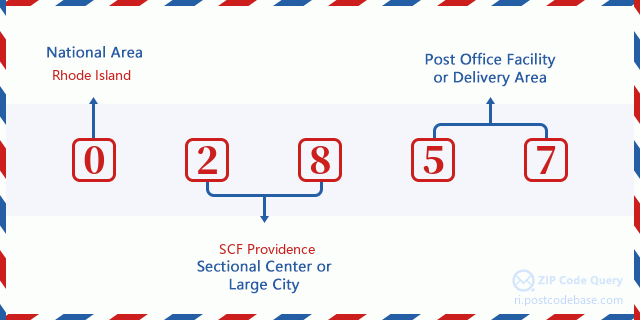
What does each digit of ZIP Code 02857 stand for?
-
The first digit designates a national area, which ranges from zero for the Northeast to nine for the far West.
The 2-3 digits represent a sectional center facility in that region.
The last two digits designate small post offices or postal zones.
Random Address in ZIP 02857

ZIP Code 02857 has 1,222 real random addresses, you can clicking the picture below to get random addresses in ZIP Code 02857.
ZIP 02857 Online Map

This is online map of the address NORTH SCITUATE, Providence County, Rhode Island. You may use button to move and zoom in / out. The map information is for reference only.
ZIP 02857 NearBy ZIP Code
The Nearby ZIP Codes are 02825, 02815, 02829, 02831, and 02814, you can find ZIP codes in a 25km radius around ZIP Code 02857 and the approximate distance between the two ZIP codes.
The data has a slight deviation for your reference only.
| ZIP Code | Distance (Kilo Meters) |
|---|---|
| 02825 | 5.612 |
| 02815 | 6.136 |
| 02829 | 8.108 |
| 02831 | 9.282 |
| 02814 | 9.809 |
| 02828 | 9.903 |
| 02919 | 10.442 |
| 02921 | 12.521 |
| 02823 | 12.657 |
| 02917 | 13.065 |
| 02839 | 13.25 |
| 06243 | 13.683 |
| 02824 | 14.416 |
| 02816 | 14.494 |
| 02911 | 14.607 |
| 02858 | 15.691 |
| 02920 | 15.79 |
| 02827 | 16.221 |
| 02909 | 16.226 |
| 02830 | 16.592 |
| 02826 | 17.04 |
| 02859 | 17.081 |
| 02908 | 17.103 |
| 02904 | 17.468 |
| 02918 | 17.488 |
| 02893 | 17.927 |
| 06239 | 18.016 |
| 02910 | 18.171 |
| 02907 | 18.452 |
| 06241 | 18.594 |
| 02896 | 18.738 |
| 06377 | 18.853 |
| 06233 | 19.03 |
| 02901 | 19.129 |
| 02902 | 19.129 |
| 02940 | 19.129 |
| 02903 | 19.435 |
| 02865 | 19.786 |
| 02912 | 20.027 |
| 02886 | 20.086 |
| 06260 | 20.334 |
| 02876 | 20.609 |
| 02905 | 20.707 |
| 02906 | 20.865 |
| 02888 | 20.999 |
| 02802 | 21.166 |
| 02838 | 21.313 |
| 02860 | 21.471 |
| 06354 | 21.53 |
| 02817 | 21.697 |
| 06373 | 21.771 |
| 06263 | 21.868 |
| 02863 | 22.024 |
| 02862 | 22.478 |
| 02864 | 22.841 |
| 02895 | 22.849 |
| 02914 | 23.337 |
| 06387 | 23.999 |
| 06332 | 23.999 |
| 02916 | 24.036 |
| 02818 | 24.3 |
| 01529 | 24.685 |
| 06277 | 24.736 |
| 02861 | 24.814 |
| 02915 | 24.913 |
| 02889 | 24.918 |

Library in ZIP Code 02857

-
NORTH SCITUATE PUBLIC LIBRARY
Phone: (401) 647-5133Address: 606 WEST GREENVILLE ROAD, SCITUATE RI 02857, USA
School in ZIP Code 02857

This is the ZIP Code 02857 - School page list. Its detail School Name, Address, City, State, ZIP Code is as below.
| School Name | Address | City | State | Grades | ZIP Code |
|---|---|---|---|---|---|
| Fogarty Memorial | 736 Snake Hill Road | North Scituate | Rhode Island | KG-5 | 02857 |
| North Scituate School | 46 Institute Lane | North Scituate | Rhode Island | KG-5 | 02857 |
| Ponaganset High School | 137 Anan Wade Road | North Scituate | Rhode Island | 9-12 | 02857 |
| Ponaganset Middle School | 91 Anan Wade Road | North Scituate | Rhode Island | 6-8 | 02857 |
| Scituate High School | 94 Trimtown Road | North Scituate | Rhode Island | 9-12 | 02857 |
| Scituate Middle School | 94 Trimtown Road | North Scituate | Rhode Island | 6-8 | 02857 |
Comment


Add new comment